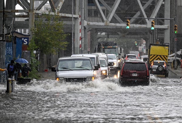
Photographs and videos of New York City have shown rainwater spurting from between subway station tiles, cars bobbing in floodwaters that turned Brooklyn intersections into lakes and parts of LaGuardia Airport inundated as the city and surrounding areas have been deluged by heavy downpours on Friday.
Between midnight and the afternoon, rainfall rates up to two inches per hour dropped more than five inches of water on Central Park and more than eight inches on John F. Kennedy International Airport—a record for any calendar day in the latter. That precipitation overwhelmed ground that was already well saturated from the previous weekend’s rains (courtesy of the remnants of Tropical Storm Ophelia) and the storm drains and subway pumps used to funnel rainwater away.
The rain has been reminiscent of what might happen in a tropical system—and has reminded many New Yorkers of Hurricane Ida’s deadly flooding two years ago—though the exact mechanics were a bit different in this case. Here Scientific American answers some questions readers may have about this and similar events—particularly how climate change comes into play.
On supporting science journalism
If you're enjoying this article, consider supporting our award-winning journalism by subscribing. By purchasing a subscription you are helping to ensure the future of impactful stories about the discoveries and ideas shaping our world today.
How does this compare with other major rain events in New York City’s history?
We can’t say exactly where this event will rank because the rain is still falling, but comparing it to Ida is not off base. Ida’s peak rainfall rates were higher—about three inches per hour—and it dropped 7.13 inches on September 1, 2021, the worst day of rain during that storm. And though the current storm has caused major flash flooding, “we haven’t seen the catastrophic flash flooding” that happened during Ida and killed 11 people in basement apartments in Queens, says Dominic Ramunni, a meteorologist at the National Weather Service’s office in Upton, N.Y.
This event has dropped more rain than Ida did on JFK Airport, though—it is the most rain the airport has recorded since records began in 1948. Every storm is a little different, and where the heaviest bands of rain form can vary, which means some areas experience higher totals in some storms than in others. “That's why we see this variability from event to event,” Ramunni says.
How do you get such a deluge without the involvement of a tropical storm?
Though tropical cyclones (the broad term for tropical storms, hurricanes and typhoons) are notorious for the torrents of rain they can bring, nontropical systems are capable of causing heavy downpours if they have enough moisture available.
Tropical systems are driven by convection that is fueled by warm ocean waters. They often develop a clear “eye” at their center that is completely surrounded by swirling thunderstorms. That setup has not been present with the system over New York City on Friday.
Rather that system has been driven in part by an area of low pressure to the south of the city that is an offshoot of another, more unusual area of low pressure called an “inverted trough.” In meteorological speak, that means it has caused a northward bulge in the atmosphere instead of a more typical southward one. The whole setup has made moisture-laden air converge and rise upward. As it has risen, the air has cooled and formed clouds and rain. That moisture has been funneled onshore like a hose aimed at the city.
How does climate change factor into the situation?
It would take a specific study—called an attribution study—to give any hard numbers on how much more likely this event would be with climate change than without it. But broadly speaking, scientists know that rising global temperatures are making heavy downpours more likely.
The 2018 National Climate Assessment (a new version of which is due sometime this year) found that the amount of rain that fell during the heaviest 1 percent of rain events had increased by 55 percent across the Northeast since 1958, with most of the increase happening since 1996. That trend will only get worse as global temperature rise, causing more evaporation from oceans and lakes and giving storms more water to fuel deluges.
How can I stay more aware of pending storms and flooding threats?
Ramunni says that having more than one source for receiving extreme weather alerts is ideal. These resources can include alerts that government agencies send out to your phone, local news and a weather radio.
When forecasters issue a watch for a flood (or other type of weather event such as a tornado), it indicates that people should be prepared for those conditions in their area. If a warning is issued, that means they should take immediate action.
In the case of floods, one of the biggest warnings meteorologists give is to never, ever drive into floodwaters, even if they don't seem very deep. Just six inches of water can reach the bottom of the average passenger car and cause loss of control, and only a foot of water can float many vehicles.
Could this event have been even worse?
Amazingly, yes. Meteorologist Mark Bove noted on X, formerly known as Twitter, that the highest rains from the storm occurred just offshore and totaled more than 8.5 inches. If that had fallen over the city, it would have been “the worst #flooding disaster the city has ever experienced,” he wrote.